
Blogs
10 Images of Volcanoes as Seen from Space
A new perspective
Spouting fire and noxious gases, volcanoes have alternatively inspired and frightened people since the dawn of time. There’s the epic Santorini eruption of Greece in 1650 B.C. that killed millions and is thought to have wiped the Minoan civilization off the planet. Mount Vesuvius erupted in 79 A.D., famously burying the cities of Pompeii and Herculaneum in 75 feet of ash. In 1883, as much as two thirds of the island of Krakatau in Indonesia was blasted 75,000 feet into the atmosphere when a volcano erupted.
Now, thanks to the various Earth-observing satellites of NASA, we can see epic eruptions as never before. Pictured here is the Eyjafjallajökull volcano in Iceland on April 17, 2010. According to NASA, this false-color image shows "a strong thermal source (denoted in red) visible at the base of the Eyjafjallajökull plume." It was taken by the Advanced Land Imager (ALI) instrument aboard NASA's Earth Observing-1 (EO-1) spacecraft. Here are some oddly beautiful images of volcanoes as seen from space.

Mayon
This natural-color image of Mayon Volcano in the Philippines was captured by the ALI instrument on NASA's EO-1 spacecraft on Dec. 15, 2009. A plume of ash and smoke drifts west, away from the summit. The traces of past eruptions are clearly visible. "Dark-colored lava or debris flows from previous eruptions streak the flanks of the mountain. A ravine on the southeast slope is occupied by a particularly prominent lava or debris flow," NASA writes.
suggested read: 20 Seriously Weird Places Around The World
Mayon's perfect conical appearance makes it a popular tourist destination, but is one of the most active volcanoes in the Philippines, erupting 47 times since 1616. On Jan. 13, 2018, an eruption of smoke and ash was recorded in the early morning, with a steady increase in volcanic activity over the following days. By Jan. 23, lava fountains were observed shooting in to the sky and residents were evacuated from their homes.

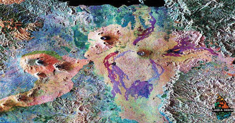
Mount Merapi in Indonesia
In another false-color image from NASA, we see Mount Merapi on June 6, 2006, after a major eruption prompted the evacuation of more than 10,000 area villagers. NASA explains this image: "red indicates vegetation, and the brighter the red, the more robust the plant life. Clouds appear as bright, opaque white, and the volcanic plume appears as a dingy gray cloud blowing toward the southwest." Experts felt that powerful earthquakes in the region prior to the eruption may have contributed to the volcanic blast. Mount Merapi erupted again in late 2010, killing more than 350 people.

Mount Belinda in the South Sandwich Islands
This false-color image comes from Montagu Island in the South Sandwich Islands, which are located between South America and Antarctica. Mount Belinda was inactive until late 2001, when it began erupting. The image was taken on Sept. 23, 2005, by the Advanced Spaceborne Thermal Emission and Reflection Radiometer (ASTER) riding NASA's Terra satellite. As NASA describes the image, "red indicates hot areas, blue indicates snow, white indicates steam, and gray indicates volcanic ash." Steam is sent up in a plume from where the hot lava meets the ocean.

...[ Continue to next page ]
Comments